Read a weather map
Help Questions
Earth Science › Read a weather map

What type of front is depicted in the image?
a cold front
a warm front
an occluded front
a stationary front
Explanation
The answer is "a cold front."
A front is a boundary between two air masses.
Cold fronts are designated by lines of blue triangles.
Warm fronts are designated by lines of red semi circles.
A stationary front has both of a cold and warm front on the same line facing opposite directions. An occluded front has both a warm and cold front traveling in the same direction.
On weather maps, high pressure systems have an “H” at the center. High pressure systems bring cold air and spin outward.
Low pressure systems are marked with an “L.” They spin inward and bring warm air.
A weather map has closely space isobars. What type of weather would you expect to be present?
high winds
high temperatures
clear skies
low moisture
Explanation
The answer is "high winds" because isobars represent changes in air pressure, and wind is caused by differences in air pressure.
A front is a boundary between two air masses.
Cold fronts are designated by lines of blue triangles.
Warm fronts are designated by lines of red semi circles.
A stationary front has both of a cold and warm front on the same line facing opposite directions. An occluded front has both a warm and cold front traveling in the same direction.
On weather maps, high pressure systems have an “H” at the center. High pressure systems bring cold air and spin outward.
Low pressure systems are marked with an “L.” They spin inward and bring warm air.

Based on this simplified weather map, how would you expect the weather in Austin, Texas to compare to the weather in San Antonio, Texas?
Austin will have lower temperatures in the next few days.
Austin will have higher temperatures in the next few days.
Austin will have high winds in the next few days.
Austin will have lower moisture in the next few days.
Explanation
The answer is "Austin will have lower temperatures in the next few days."
A front is a boundary between two air masses.
Cold fronts are designated by lines of blue triangles.
Warm fronts are designated by lines of red semi circles.
A stationary front has both of a cold and warm front on the same line facing opposite directions. An occluded front has both a warm and cold front traveling in the same direction.
On weather maps, high pressure systems have an “H” at the center. High pressure systems bring cold air and spin outward.
Low pressure systems are marked with an “L.” They spin inward and bring warm air.

What does the letter "H" represent in the image above?
high pressure air masses
high winds
high chance of rain
heavy thunderstorms
Explanation
The answer is "high pressure air masses."
A front is a boundary between two air masses.
Cold fronts are designated by lines of blue triangles.
Warm fronts are designated by lines of red semi circles.
A stationary front has both of a cold and warm front on the same line facing opposite directions. An occluded front has both a warm and cold front traveling in the same direction.
On weather maps, high pressure systems have an “H” at the center. High pressure systems bring cold air and spin outward.
Low pressure systems are marked with an “L.” They spin inward and bring warm air.

What type of front is pictured in the weather map above?
a stationary front
an occluded front
a cold front
a warm front
Explanation
The answer is "a stationary front."
A front is a boundary between two air masses.
Cold fronts are designated by lines of blue triangles.
Warm fronts are designated by lines of red semi circles.
A stationary front has both of a cold and warm front on the same line facing opposite directions. An occluded front has both a warm and cold front traveling in the same direction.
On weather maps, high pressure systems have an “H” at the center. High pressure systems bring cold air and spin outward.
Low pressure systems are marked with an “L.” They spin inward and bring warm air.

What type of front is depicted in the image?
an occluded front
a stationary front
a cold front
a warm front
Explanation
The answer is "an occluded front."
A front is a boundary between two air masses.
Cold fronts are designated by lines of blue triangles.
Warm fronts are designated by lines of red semi circles.
A stationary front has both of a cold and warm front on the same line facing opposite directions. An occluded front has both a warm and cold front traveling in the same direction.
On weather maps, high pressure systems have an “H” at the center. High pressure systems bring cold air and spin outward.
Low pressure systems are marked with an “L.” They spin inward and bring warm air.

What type of weather is pictured in the image?
a stationary front, gentle rains
a stationary front, thunderstorms
an occluded front, thunderstorms
an occluded front, clear skies
Explanation
The answer is "a stationary front, gentle rains." Even though stationary fronts usually produce clear skies, this map has a green region to represent rain. It would not be a thunderstorm because a stationary front is not likely to produce that type of weather.
A front is a boundary between two air masses.
Cold fronts are designated by lines of blue triangles.
Warm fronts are designated by lines of red semi circles.
A stationary front has both of a cold and warm front on the same line facing opposite directions. An occluded front has both a warm and cold front traveling in the same direction.
On weather maps, high pressure systems have an “H” at the center. High pressure systems bring cold air and spin outward.
Low pressure systems are marked with an “L.” They spin inward and bring warm air.

Which of the following best describes the weather in the weather map above?
low pressure systems, a cold front, and rain
low pressure systems, a warm front, and rain
low moisture, a cold front, and rain
low moisture, a warm front, and rain
Explanation
The answer is "low pressure systems, a cold front, and rain."
A front is a boundary between two air masses.
Cold fronts are designated by lines of blue triangles.
Warm fronts are designated by lines of red semi circles.
A stationary front has both of a cold and warm front on the same line facing opposite directions. An occluded front has both a warm and cold front traveling in the same direction.
On weather maps, high pressure systems have an “H” at the center. High pressure systems bring cold air and spin outward.
Low pressure systems are marked with an “L.” They spin inward and bring warm air.

What type of front is depicted in the image?
a warm front
a cold front
a stationary front
an occluded front
Explanation
The answer is "a warm front."
A front is a boundary between two air masses.
Cold fronts are designated by lines of blue triangles.
Warm fronts are designated by lines of red semi circles.
A stationary front has both of a cold and warm front on the same line facing opposite directions. An occluded front has both a warm and cold front traveling in the same direction.
On weather maps, high pressure systems have an “H” at the center. High pressure systems bring cold air and spin outward.
Low pressure systems are marked with an “L.” They spin inward and bring warm air.
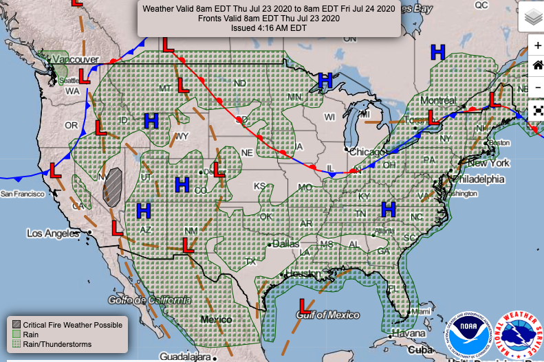
Which of the following best explains why most of the continental United States is experiencing thunderstorms?
the collision of high and low air pressure systems
rising moisture in the atmosphere
high temperatures combined and low pressure systems
low temperatures with and high pressure systems
Explanation
The answer is "the collision of high and low air pressure systems."
A front is a boundary between two air masses.
Cold fronts are designated by lines of blue triangles.
Warm fronts are designated by lines of red semi-circles.
A stationary front has both a cold and warm front on the same line facing opposite directions. An occluded front has both a warm and cold front traveling in the same direction.
On weather maps, high-pressure systems have an “H” at the center. High-pressure systems bring cold air and spin outward.
Low-pressure systems are marked with an “L.” They spin inward and bring warm air.