All questions
Question 1
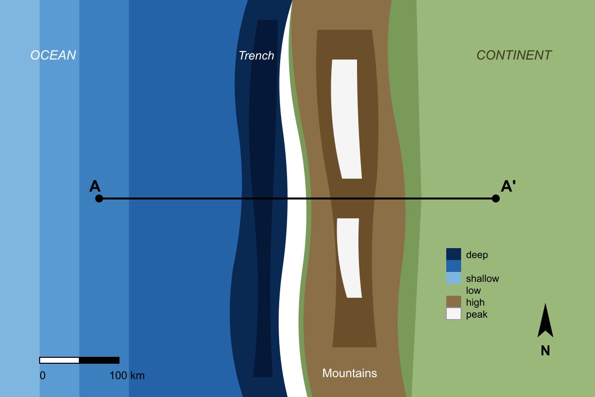
The map is a bathymetric and topographic map of a tectonically active region. Based on the features shown, what type of plate boundary most likely exists along the line from A to A'?
- A continental collision zone, where two continents are converging.
- A mid-ocean ridge, where two oceanic plates are diverging.
- An oceanic-continental subduction zone, where an oceanic plate sinks under a continent. (correct answer)
- A transform fault, where two plates are sliding past one another horizontally.
Explanation: The map shows several key features along the line A-A'. There is a very deep linear feature offshore (a deep-sea trench), which is characteristic of subduction. On the continent adjacent to the trench, there is a high-elevation mountain range that runs parallel to the trench. This combination of a deep trench and a coastal volcanic mountain range is the classic signature of an oceanic plate subducting beneath a continental plate.
Question 2
The Wilson Cycle describes the life cycle of ocean basins. The map shows four locations (A, B, C, D) representing different tectonic environments. Which location best represents the 'mature' stage of the Wilson Cycle?
- Location A, a zone of continental collision.
- Location B, a narrow sea with a central rift.
- Location C, a wide ocean basin with passive continental margins. (correct answer)
- Location D, an area of initial continental rifting.
Explanation: The 'mature' stage of the Wilson Cycle is characterized by a wide, well-developed ocean basin with a mid-ocean ridge system and passive continental margins where sediment accumulates. The Atlantic Ocean is the classic example. Location C on the map depicts such a setting. Location D (embryonic stage), Location B (juvenile stage), and Location A (suturing/terminal stage) represent other phases of the cycle.
Question 3
The map displays a continent with two distinct coastlines, labeled X and Y. Coastline X coincides with a plate boundary, while coastline Y is located in the interior of a tectonic plate. Based on this information, which statement accurately compares the two continental margins?
- Margin X is active, with a narrow continental shelf and frequent seismicity; Margin Y is passive, with a wide continental shelf and little seismicity. (correct answer)
- Margin X is passive, characterized by extensional tectonics; Margin Y is active, characterized by compressional tectonics.
- Both margins are active, but Margin X is convergent while Margin Y is divergent.
- Margin X is a transform margin with horizontal motion; Margin Y is a passive margin with significant vertical uplift.
Explanation: A continental margin that is also a plate boundary is called an active margin. Active margins are characterized by tectonic activity like earthquakes and volcanism, and typically have steep, narrow continental shelves. A continental margin that is not a plate boundary is called a passive margin. These are tectonically quiet and are characterized by wide continental shelves built from sediment accumulation. Therefore, Margin X is active and Margin Y is passive, matching the description in A.
Question 4
The diagram illustrates the process of trench rollback, where a subducting slab sinks into the mantle and the position of the trench moves seaward over time (from T1 to T2). The overriding plate is also moving toward the trench. Which tectonic regime is most likely to develop in the overriding plate as a direct result of this process?
- A regime of intense compression, leading to crustal shortening and thickening.
- A regime of extension, leading to crustal thinning and back-arc rifting. (correct answer)
- A regime dominated by large-scale transform faulting parallel to the trench.
- A tectonically stable regime with a complete cessation of volcanism and seismicity.
Explanation: Trench rollback occurs when the subducting slab sinks vertically into the mantle faster than the overriding plate can advance. This causes the 'hinge' of the subduction zone to migrate away from the overriding plate. Even if the overriding plate is moving forward, if the trench is rolling back faster, the net effect on the overriding plate is tension. This tensional stress leads to crustal thinning, rifting, and the formation of a back-arc basin.
Question 5
The diagram shows a mid-ocean ridge offset by a transform fault. Based on the direction of seafloor spreading indicated by the arrows, what is the relative motion along the segment of the fracture zone between points X and Y?
- Point X is moving east relative to point Y (right-lateral motion).
- Point X is moving west relative to point Y (left-lateral motion). (correct answer)
- Points X and Y are moving apart from each other (divergence).
- There is no relative motion between points X and Y.
Explanation: This question tests the understanding of motion along a transform fault. The seafloor is spreading away from the ridge crests. On the northern ridge segment, new crust moves to the east and west. On the southern ridge segment, new crust also moves east and west. Between the two ridge segments (the active transform fault), the plate on the north side is moving west, and the plate on the south side is moving east. Therefore, between points X and Y, the motion is strike-slip. Standing at Y and looking at X, X is moving to the west (left). This is left-lateral motion. A common mistake is to assume the motion matches the offset of the ridge, which would imply right-lateral motion.
Question 6
The map shows the present-day Atlantic Ocean, with the Mid-Atlantic Ridge and several magnetic anomaly stripes. Anomaly 34, which formed 83 million years ago, is identified. Which statement best describes the configuration of the continents 83 million years ago?
- The continents were in their present-day positions, but the ocean was much shallower.
- The continents were significantly farther apart than they are today.
- The continents were closer together, with the locations of Anomaly 34 on each plate meeting at the Mid-Atlantic Ridge. (correct answer)
- South America was connected to Africa, but North America and Europe were separated by a wide ocean.
Explanation: Magnetic anomalies on the seafloor record the position of the spreading ridge at the time they formed. To reconstruct the past position of continents, one can reverse the process of seafloor spreading. By moving the continents toward the Mid-Atlantic Ridge until the Anomaly 34 stripes on both the South American/North American plates and the African/Eurasian plates line up at the ridge axis, we can see the configuration of the plates 83 million years ago. This position would be significantly closer together than today, but not fully connected as they were in Pangaea.
Question 7
The relative motion between two rigid plates on a sphere can be described as a rotation about a point called an Euler pole. The map shows the boundary between Plate A and Plate B and the location of their Euler pole. How does the magnitude of the relative velocity at Point 1 compare to the magnitude of the relative velocity at Point 2?
- The velocity at Point 1 is greater than at Point 2.
- The velocity at Point 2 is greater than at Point 1. (correct answer)
- The velocities at both points are identical.
- The velocity at Point 1 is purely divergent, while the velocity at Point 2 is purely transform.
Explanation: In plate tectonics, the angular velocity of rotation around the Euler pole is constant for the entire plate. However, the linear velocity (speed) at any point on the plate boundary depends on its distance from the Euler pole. The relationship is v = ωr, where v is linear velocity, ω is angular velocity, and r is the distance from the pole. Therefore, the velocity is zero at the pole and increases to a maximum at a distance of 90 degrees (the rotational equator). Since Point 2 is farther from the Euler pole than Point 1, its linear velocity is greater.