All questions
Question 1
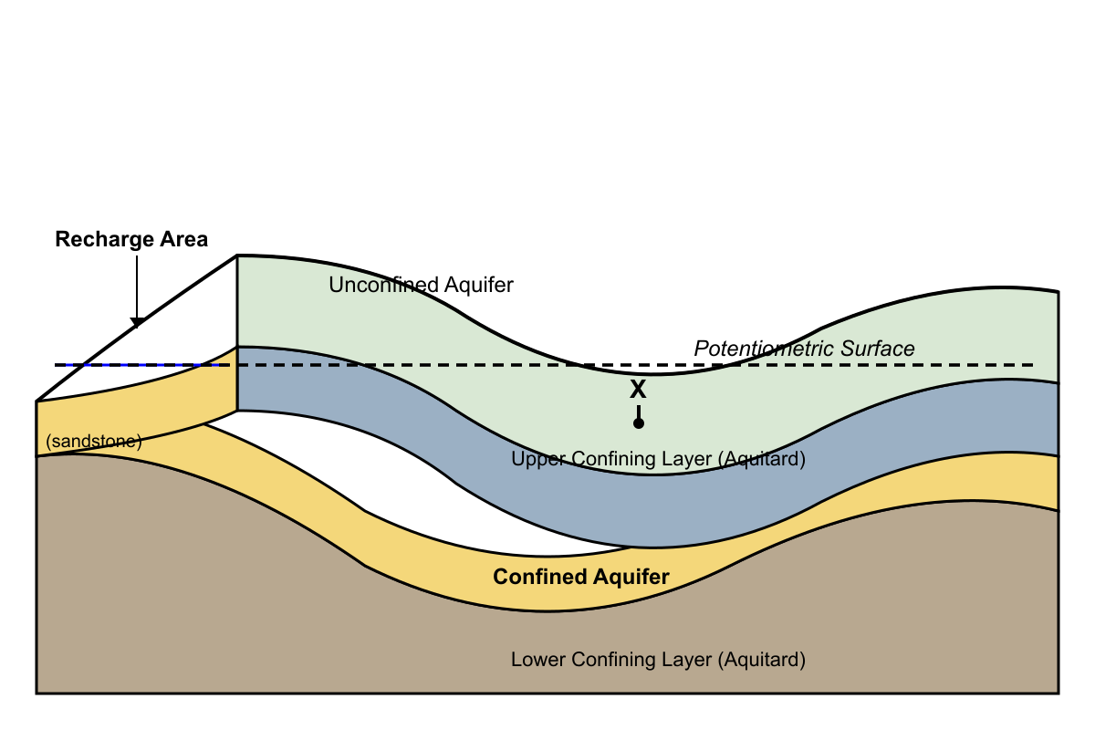
The diagram shows a cross-section of a confined aquifer system. The dashed line represents the potentiometric surface. Under which condition would a well drilled at Location X result in a flowing artesian well?
- Only if the well is drilled deep enough to reach the lower confining layer.
- Under all conditions, because any well in a confined aquifer is a flowing artesian well.
- Only if the ground surface at Location X were below the potentiometric surface. (correct answer)
- Only if the recharge area receives an exceptional amount of rainfall.
Explanation: A confined aquifer contains water under pressure. The potentiometric surface represents the height to which water will rise in a well drilled into the aquifer. A well becomes a flowing artesian well only if the pressure is sufficient to push the water up to and above the ground surface. This occurs when the ground surface at the well's location is at a lower elevation than the potentiometric surface.
Question 2
For over a century, a city has withdrawn large amounts of groundwater from a system of sand aquifers interbedded with thick clay aquitards. The city has experienced several inches of land subsidence. What is the primary mechanism causing this subsidence?
- The dissolution of minerals in the sand layers, causing them to weaken and collapse.
- The removal of water from the sand aquifers reduces fluid pressure, allowing the compaction of the adjacent clay aquitards. (correct answer)
- The weight of the city's buildings and infrastructure has slowly compressed all the underlying layers.
- The creation of underground voids as fine sand particles are pumped out along with the water.
Explanation: This describes classic land subsidence from groundwater withdrawal. The water in the pore spaces of sediments helps support the overlying material. When water is pumped from the sand aquifers, the fluid pressure (hydraulic head) drops. This increases the effective stress on the sediment skeleton. While the sand layers compact slightly, the majority of the compaction occurs in the adjacent, highly porous clay aquitards, which slowly dewater and compress like a squeezed sponge, resulting in subsidence at the surface.
Question 3
An unconfined aquifer has a hydraulic gradient of 0.005. Due to a prolonged period of increased precipitation and recharge, the slope of the water table doubles, resulting in a new hydraulic gradient of 0.010. Assuming the permeability of the aquifer material remains constant, what is the most direct consequence of this change?
- The porosity of the aquifer will decrease by half.
- The velocity of groundwater flow will approximately double. (correct answer)
- The amount of water stored in the aquifer (storativity) will double.
- The permeability of the aquifer will increase to compensate for the change.
Explanation: According to Darcy's Law, the velocity of groundwater flow is directly proportional to the hydraulic gradient (the slope of the water table). If the hydraulic gradient doubles and the permeability (hydraulic conductivity) remains the same, the velocity of the groundwater flow will also approximately double. Porosity and permeability are physical properties of the aquifer material and do not change in response to the hydraulic gradient.
Question 4
Two industrial facilities build high-capacity wells near each other, pumping from the same unconfined aquifer. When both wells operate simultaneously, a phenomenon known as well interference occurs. Which statement best describes this phenomenon?
- The cones of depression of the two wells overlap, causing less overall drawdown in the aquifer.
- The wells compete for the same water, causing a greater drawdown in each well than if it were pumping alone. (correct answer)
- One well reverses the flow of groundwater, causing the other well to become contaminated.
- The pumping action creates a permanent underground barrier, preventing flow between the wells.
Explanation: When the cones of depression from two or more pumping wells overlap, they create a composite cone of depression that is larger and deeper than any of the individual cones. This means that the drawdown (the lowering of the water level) at each well is increased. The wells are essentially competing for the same volume of water, and the efficiency of each well is reduced.
Question 5
A geologist is searching for a rock layer to act as an effective aquitard or confining layer for a hazardous waste disposal site. Which of the following materials would be the best choice?
- Well-sorted, coarse-grained sand, because it has high porosity to absorb liquids.
- Cavernous limestone, because its large open spaces can contain the waste.
- Highly fractured granite, because the cracks will allow waste to disperse evenly.
- Dense, unfractured clay, because its low permeability will prevent the migration of fluids. (correct answer)
Explanation: An aquitard is a layer that restricts the flow of groundwater. The most important property for an aquitard is very low permeability. Clay has very small, poorly connected pore spaces, giving it extremely low permeability, even though it can have high porosity. Sand, cavernous limestone, and fractured granite all have high permeability and would make poor confining layers, as they would allow the hazardous waste to migrate easily.
Question 6
A small island community depends entirely on a lens-shaped freshwater aquifer surrounded by saline groundwater. If the community's population grows and the rate of water extraction from the well significantly increases, what is the most probable and severe long-term consequence?
- Land subsidence, as the removal of water causes the island's sediments to compact.
- The formation of a perched water table, leading to a more complex aquifer system.
- Saltwater intrusion, causing the well to start pumping brackish or salty water. (correct answer)
- An increase in the water table elevation due to reduced pressure in the aquifer.
Explanation: In coastal and island aquifers, a delicate balance exists between the less dense freshwater flowing from the land and the denser saltwater from the ocean. Excessive pumping of the freshwater creates a large cone of depression, which also causes the underlying saltwater/freshwater interface to rise in a phenomenon called saltwater upconing or intrusion. This can lead to the well drawing in saltwater, rendering the water supply unusable. While subsidence can occur, saltwater intrusion is the more direct and critical threat in this specific hydrogeological setting.
Question 7
A well drilled into a thick layer of volcanic ash is found to have a very high porosity of 50%. However, the well can only be pumped at an extremely low rate before it runs dry, and it recharges very slowly. What is the best explanation for this situation?
- The volcanic ash has very low permeability. (correct answer)
- The well was not drilled deep enough to reach the zone of saturation.
- The volcanic ash has very low porosity.
- The well is located in a discharge area, which prevents recharge.
Explanation: This question highlights the crucial difference between porosity and permeability. Porosity is the measure of void space in a material, determining how much water it can hold. Permeability is the measure of the ability of a material to transmit fluids, determined by the size and connectedness of the pores. The volcanic ash can hold a lot of water (high porosity), but the pores are likely very small and poorly connected, resulting in low permeability. This prevents water from flowing easily to the well, explaining the low pumping rate and slow recharge.
Question 8
In which of the following scenarios would groundwater be expected to have the longest residence time (i.e., be the 'oldest')?
- In a shallow unconfined aquifer composed of coarse gravel next to a large, gaining river.
- In a perched water table that is fed by seasonal rainfall and dries up in the summer.
- In a deep, extensive, confined aquifer with low permeability and a very low hydraulic gradient. (correct answer)
- In a karst aquifer system characterized by large, interconnected solution channels and caves.
Explanation: Residence time is the average amount of time water spends in a groundwater system. Long residence times are associated with slow movement. Groundwater moves slowest in systems with low permeability (material is not very conductive), low hydraulic gradient (less 'push'), and long flow paths. A deep, extensive confined aquifer fits this description perfectly. In contrast, shallow, high-permeability, and karst systems (A and D) have very fast flow and short residence times. Perched water tables (B) are temporary and have very short residence times.
Question 9
In an arid region, a farmer replaces an inefficient flood irrigation system with a highly efficient drip irrigation system for the same crops. While this conserves water by reducing evaporation and total water use, what is the most likely unintended consequence for the local unconfined aquifer over many years?
- A significant rise in the water table, because less water is being pumped from the aquifer overall.
- No net change in the water table, as the water consumed by the crops remains the same.
- An improvement in groundwater quality, because fertilizers are now applied more precisely.
- A gradual decline of the water table, because the artificial recharge from excess irrigation water has been eliminated. (correct answer)
Explanation: When you encounter questions about irrigation changes and groundwater effects, think about the complete water cycle in agricultural systems, not just direct water use by plants.
In flood irrigation systems, farmers typically apply much more water than crops actually need. This "excess" water serves an important but often overlooked function: it percolates down through the soil and recharges the underlying aquifer. When farmers switch to highly efficient drip irrigation, they eliminate this excess water application, delivering only what crops require directly to root zones.
Answer D correctly identifies that removing this artificial recharge will cause the water table to gradually decline over time. The aquifer was previously receiving regular inputs from irrigation overflow, and eliminating this source creates a water deficit that leads to a dropping water table.
Answer A incorrectly assumes less total pumping automatically raises water tables, but it ignores the loss of recharge from excess irrigation water. Answer B misses the key point that crop water consumption isn't the only factor affecting groundwater—the excess water that previously recharged the aquifer is gone. Answer C addresses water quality rather than water quantity and incorrectly assumes precise fertilizer application significantly impacts groundwater levels.
This represents a classic example of how efficiency improvements can have unintended environmental consequences. The "waste" water from flood irrigation wasn't truly waste—it was providing essential aquifer recharge.
Remember: In groundwater questions, always consider both inputs (recharge) and outputs (pumping, evapotranspiration) to the system, not just one side of the water balance equation.
Question 10
An unconfined aquifer has a hydraulic gradient of 0.005. Due to a prolonged period of increased precipitation and recharge, the slope of the water table doubles, resulting in a new hydraulic gradient of 0.010. Assuming the permeability of the aquifer material remains constant, what is the most direct consequence of this change?
- The porosity of the aquifer will decrease by half.
- The velocity of groundwater flow will approximately double. (correct answer)
- The amount of water stored in the aquifer (storativity) will double.
- The permeability of the aquifer will increase to compensate for the change.
Explanation: According to Darcy's Law, the velocity of groundwater flow is directly proportional to the hydraulic gradient (the slope of the water table). If the hydraulic gradient doubles and the permeability (hydraulic conductivity) remains the same, the velocity of the groundwater flow will also approximately double. Porosity and permeability are physical properties of the aquifer material and do not change in response to the hydraulic gradient.
Question 11
A well drilled into a thick layer of volcanic ash is found to have a very high porosity of 50%. However, the well can only be pumped at an extremely low rate before it runs dry, and it recharges very slowly. What is the best explanation for this situation?
- The volcanic ash has very low permeability. (correct answer)
- The well was not drilled deep enough to reach the zone of saturation.
- The volcanic ash has very low porosity.
- The well is located in a discharge area, which prevents recharge.
Explanation: This question highlights the crucial difference between porosity and permeability. Porosity is the measure of void space in a material, determining how much water it can hold. Permeability is the measure of the ability of a material to transmit fluids, determined by the size and connectedness of the pores. The volcanic ash can hold a lot of water (high porosity), but the pores are likely very small and poorly connected, resulting in low permeability. This prevents water from flowing easily to the well, explaining the low pumping rate and slow recharge.
Question 12
For over a century, a city has withdrawn large amounts of groundwater from a system of sand aquifers interbedded with thick clay aquitards. The city has experienced several inches of land subsidence. What is the primary mechanism causing this subsidence?
- The dissolution of minerals in the sand layers, causing them to weaken and collapse.
- The removal of water from the sand aquifers reduces fluid pressure, allowing the compaction of the adjacent clay aquitards. (correct answer)
- The weight of the city's buildings and infrastructure has slowly compressed all the underlying layers.
- The creation of underground voids as fine sand particles are pumped out along with the water.
Explanation: This describes classic land subsidence from groundwater withdrawal. The water in the pore spaces of sediments helps support the overlying material. When water is pumped from the sand aquifers, the fluid pressure (hydraulic head) drops. This increases the effective stress on the sediment skeleton. While the sand layers compact slightly, the majority of the compaction occurs in the adjacent, highly porous clay aquitards, which slowly dewater and compress like a squeezed sponge, resulting in subsidence at the surface.
Question 13
Two industrial facilities build high-capacity wells near each other, pumping from the same unconfined aquifer. When both wells operate simultaneously, a phenomenon known as well interference occurs. Which statement best describes this phenomenon?
- The cones of depression of the two wells overlap, causing less overall drawdown in the aquifer.
- The wells compete for the same water, causing a greater drawdown in each well than if it were pumping alone. (correct answer)
- One well reverses the flow of groundwater, causing the other well to become contaminated.
- The pumping action creates a permanent underground barrier, preventing flow between the wells.
Explanation: When the cones of depression from two or more pumping wells overlap, they create a composite cone of depression that is larger and deeper than any of the individual cones. This means that the drawdown (the lowering of the water level) at each well is increased. The wells are essentially competing for the same volume of water, and the efficiency of each well is reduced.
Question 14
In an arid region, a farmer replaces an inefficient flood irrigation system with a highly efficient drip irrigation system for the same crops. While this conserves water by reducing evaporation and total water use, what is the most likely unintended consequence for the local unconfined aquifer over many years?
- A significant rise in the water table, because less water is being pumped from the aquifer overall.
- No net change in the water table, as the water consumed by the crops remains the same.
- An improvement in groundwater quality, because fertilizers are now applied more precisely.
- A gradual decline of the water table, because the artificial recharge from excess irrigation water has been eliminated. (correct answer)
Explanation: When you encounter questions about irrigation changes and groundwater effects, think about the complete water cycle in agricultural systems, not just direct water use by plants.
In flood irrigation systems, farmers typically apply much more water than crops actually need. This "excess" water serves an important but often overlooked function: it percolates down through the soil and recharges the underlying aquifer. When farmers switch to highly efficient drip irrigation, they eliminate this excess water application, delivering only what crops require directly to root zones.
Answer D correctly identifies that removing this artificial recharge will cause the water table to gradually decline over time. The aquifer was previously receiving regular inputs from irrigation overflow, and eliminating this source creates a water deficit that leads to a dropping water table.
Answer A incorrectly assumes less total pumping automatically raises water tables, but it ignores the loss of recharge from excess irrigation water. Answer B misses the key point that crop water consumption isn't the only factor affecting groundwater—the excess water that previously recharged the aquifer is gone. Answer C addresses water quality rather than water quantity and incorrectly assumes precise fertilizer application significantly impacts groundwater levels.
This represents a classic example of how efficiency improvements can have unintended environmental consequences. The "waste" water from flood irrigation wasn't truly waste—it was providing essential aquifer recharge.
Remember: In groundwater questions, always consider both inputs (recharge) and outputs (pumping, evapotranspiration) to the system, not just one side of the water balance equation.
Question 15
An aquifer made of well-sorted sand has a porosity of 30%. However, when a sample is fully saturated and then allowed to drain under the force of gravity, only 22% of the total volume is released as water. Which statement best accounts for the 8% difference?
- This 8% represents the specific retention, which is water that adheres to sediment grains due to molecular attraction and cannot be drained by gravity. (correct answer)
- This 8% represents entrapped air that was not accounted for, meaning the true porosity is only 22%.
- This 8% represents water that is chemically bonded within the crystal structure of the sand grains.
- This 8% represents the volume lost due to the compaction of the sand once the pore pressure was released.
Explanation: Total porosity is the sum of the specific yield and the specific retention. Specific yield is the volume of water that drains by gravity. Specific retention is the volume of water that is held on the surfaces of the grains by molecular forces (adhesion and cohesion) and in microscopic pores, which does not drain by gravity. Therefore, the 8% of water that remains in the sample represents the specific retention.
Question 16
An aquifer made of well-sorted sand has a porosity of 30%. However, when a sample is fully saturated and then allowed to drain under the force of gravity, only 22% of the total volume is released as water. Which statement best accounts for the 8% difference?
- This 8% represents the specific retention, which is water that adheres to sediment grains due to molecular attraction and cannot be drained by gravity. (correct answer)
- This 8% represents entrapped air that was not accounted for, meaning the true porosity is only 22%.
- This 8% represents water that is chemically bonded within the crystal structure of the sand grains.
- This 8% represents the volume lost due to the compaction of the sand once the pore pressure was released.
Explanation: Total porosity is the sum of the specific yield and the specific retention. Specific yield is the volume of water that drains by gravity. Specific retention is the volume of water that is held on the surfaces of the grains by molecular forces (adhesion and cohesion) and in microscopic pores, which does not drain by gravity. Therefore, the 8% of water that remains in the sample represents the specific retention.
Question 17
A community is planning to build on a terrain dominated by limestone bedrock, a geology known as karst. What is the most significant groundwater-related hazard that must be evaluated before construction?
- The potential for new sinkholes to form as changes in groundwater levels or surface drainage compromise the stability of underground caverns. (correct answer)
- The extreme hardness of the groundwater, which will require all homes to have water softening systems.
- The widespread presence of impermeable limestone, making it impossible to drill successful water wells.
- The risk of land subsidence due to the compaction of clay layers within the limestone.
Explanation: Karst terrain is formed by the dissolution of soluble rock like limestone. It is characterized by sinkholes, caves, and underground drainage systems. The roofs of these underground voids can be unstable. Changes in the water table (due to pumping) or altered surface runoff patterns (due to construction) can remove the buoyant support of water or erode supporting soils, leading to the sudden and catastrophic collapse of the surface, forming new sinkholes. This is a major engineering and safety hazard. While hard water is common (B), it is not a hazard. Karst is highly permeable (making C incorrect). Subsidence is related to clay compaction, not typically limestone dissolution (making D incorrect).
Question 18
A small island community depends entirely on a lens-shaped freshwater aquifer surrounded by saline groundwater. If the community's population grows and the rate of water extraction from the well significantly increases, what is the most probable and severe long-term consequence?
- Land subsidence, as the removal of water causes the island's sediments to compact.
- The formation of a perched water table, leading to a more complex aquifer system.
- Saltwater intrusion, causing the well to start pumping brackish or salty water. (correct answer)
- An increase in the water table elevation due to reduced pressure in the aquifer.
Explanation: In coastal and island aquifers, a delicate balance exists between the less dense freshwater flowing from the land and the denser saltwater from the ocean. Excessive pumping of the freshwater creates a large cone of depression, which also causes the underlying saltwater/freshwater interface to rise in a phenomenon called saltwater upconing or intrusion. This can lead to the well drawing in saltwater, rendering the water supply unusable. While subsidence can occur, saltwater intrusion is the more direct and critical threat in this specific hydrogeological setting.
Question 19
A community is planning to build on a terrain dominated by limestone bedrock, a geology known as karst. What is the most significant groundwater-related hazard that must be evaluated before construction?
- The potential for new sinkholes to form as changes in groundwater levels or surface drainage compromise the stability of underground caverns. (correct answer)
- The extreme hardness of the groundwater, which will require all homes to have water softening systems.
- The widespread presence of impermeable limestone, making it impossible to drill successful water wells.
- The risk of land subsidence due to the compaction of clay layers within the limestone.
Explanation: Karst terrain is formed by the dissolution of soluble rock like limestone. It is characterized by sinkholes, caves, and underground drainage systems. The roofs of these underground voids can be unstable. Changes in the water table (due to pumping) or altered surface runoff patterns (due to construction) can remove the buoyant support of water or erode supporting soils, leading to the sudden and catastrophic collapse of the surface, forming new sinkholes. This is a major engineering and safety hazard. While hard water is common (B), it is not a hazard. Karst is highly permeable (making C incorrect). Subsidence is related to clay compaction, not typically limestone dissolution (making D incorrect).
Question 20
The diagram provided shows a cross-section of a river and the adjacent water table. Based on the relationship shown, what can be inferred about the river and the groundwater system?
- The river is a 'losing stream', contributing water to the aquifer, which is common in arid climates.
- The river is a 'gaining stream', receiving water from the aquifer, which is common in humid climates. (correct answer)
- The river is disconnected from the groundwater system by an impermeable layer.
- The groundwater is flowing parallel to the river and does not interact with it.
Explanation: The diagram shows the water table elevation on both sides of the river is higher than the river's water surface. This creates a hydraulic gradient where groundwater flows towards the river and discharges into it. A stream that receives water from the groundwater system is called a 'gaining stream' or 'effluent stream'. This condition is typical in humid regions where the water table is generally high.