All questions
Question 1
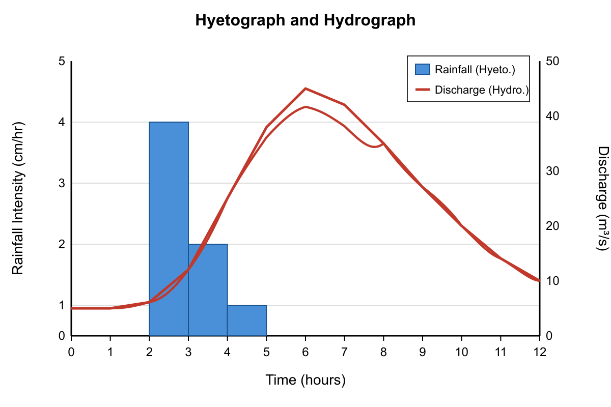
The graph shows a rainfall event (hyetograph) and the resulting streamflow response (hydrograph) for a watershed. Based on an analysis of the two data series, what is the approximate basin lag time?
- 2 hours
- 4 hours (correct answer)
- 6 hours
- 10 hours
Explanation: Basin lag time is defined as the time difference between the center of mass of the rainfall event and the peak of the resulting hydrograph. A common approximation is the time from the peak rainfall intensity to the peak stream discharge. In the graph, the peak rainfall intensity occurs at hour 2. The peak stream discharge occurs at hour 6. The lag time is the difference between these two peaks: 6 hours - 2 hours = 4 hours.
Question 2
Drainage density is the total length of all stream channels in a basin divided by the area of that basin. Consider two basins of equal area: Basin X consists of impermeable clay soils with sparse vegetation, while Basin Y has porous sandy soils and is covered by a dense forest. Which basin is expected to have a higher drainage density, and why?
- Basin X, because low infiltration rates lead to greater surface runoff, which carves more channels. (correct answer)
- Basin Y, because the dense root systems of the forest create numerous small channels for water.
- Both basins will have nearly identical drainage densities because their areas are equal.
- Basin X, because the clay soils are heavier and compress the ground, creating more space for streams.
Explanation: When you encounter drainage density questions, focus on the relationship between surface water flow and channel formation. Drainage density increases when more water flows over the surface rather than soaking into the ground, because surface runoff is what carves and maintains stream channels.
Basin X's impermeable clay soils prevent water from infiltrating into the ground, forcing most precipitation to flow as surface runoff. This abundant surface water creates and maintains numerous stream channels. The sparse vegetation provides little protection against erosion and doesn't significantly increase infiltration rates. Additionally, with minimal plant roots to hold soil together, the surface is more susceptible to channel formation by flowing water.
Let's examine why the other options miss the mark. Option B incorrectly suggests that forest root systems create drainage channels - in reality, roots help water infiltrate into soil and actually reduce surface runoff, leading to fewer stream channels. Option C makes the fundamental error of assuming drainage density depends only on basin area, when it's actually determined by the balance between surface runoff and infiltration. Option D presents a nonsensical explanation about clay weight creating stream space, which has no basis in hydrology - soil compression doesn't create drainage networks.
The correct answer is A because low infiltration in clay soils maximizes surface runoff, which carves more channels per unit area.
Study tip: Remember that drainage density is inversely related to infiltration capacity. High infiltration (sandy soils, dense vegetation) means low drainage density, while low infiltration (clay soils, sparse vegetation) means high drainage density.
Question 3
A geomorphologist studying a wide river valley observes several oxbow lakes, abandoned meander scars, and natural levees composed of fine sand and silt. These features collectively provide the strongest evidence for which conclusion about the river's long-term behavior?
- The river has been consistently downcutting due to a falling base level.
- The river is geologically young and has not had time to establish a stable floodplain.
- The river has undergone significant lateral migration and periodic overbank flooding. (correct answer)
- The river's flow is primarily controlled by a system of underlying geologic faults and joints.
Explanation: Oxbow lakes and meander scars are direct evidence of the lateral (side-to-side) migration of a meandering river channel over time. Natural levees are ridges of sediment deposited along the channel banks during floods when the river overtops its banks. The presence of all these features indicates a mature river system that actively shifts its course across a floodplain and experiences regular flood events that are part of its natural cycle.
Question 4
A particular location on a river experienced a flood in 2015 that was statistically determined to be a '100-year flood.' Which statement most accurately describes the likelihood of a flood of the same magnitude or greater occurring in 2016?
- The probability is 1%, as the occurrence of the flood in the previous year does not change its statistical probability for any given year. (correct answer)
- The probability is virtually zero, as a 100-year flood can only happen once in a century.
- The probability is now 1/99, as one year of the 100-year cycle has passed.
- The probability is much less than 1%, because flood events of that magnitude are typically followed by long periods of lower flows.
Explanation: The term '100-year flood' refers to a flood event that has a 1 in 100, or 1%, chance of being equaled or exceeded in any given year. Each year is treated as an independent statistical event. The occurrence of a 100-year flood in one year has no bearing on the probability of it occurring the next year. Therefore, the probability remains 1%.
Question 5
A steep, sediment-laden mountain stream emerges from a confined canyon and spreads out onto a broad, flat desert plain. This sudden decrease in gradient and confinement will cause the stream to deposit much of its sediment, forming which type of landform?
- A delta
- A point bar
- A natural levee
- An alluvial fan (correct answer)
Explanation: An alluvial fan is a fan- or cone-shaped deposit of sediment built up by streams. They are common in arid and semi-arid regions where a stream flowing out of a steep, narrow canyon experiences a rapid decrease in slope and flow confinement. This causes the stream to lose energy and deposit its sediment load. A delta forms where a river enters a standing body of water, a point bar forms on the inside of a meander, and a natural levee forms along the banks during a flood.
Question 6
A drop of rain falls at a location with coordinates 44° N, 110° W, which is within Yellowstone National Park, Wyoming, just west of the Continental Divide. Assuming it flows into a stream and is not evaporated, into which major body of water will it ultimately drain?
- The Gulf of Mexico
- The Hudson Bay
- The Pacific Ocean (correct answer)
- The Great Salt Lake
Explanation: The Continental Divide of the Americas separates watersheds that drain to the Pacific Ocean from those that drain to the Atlantic and Arctic Oceans (including the Gulf of Mexico and Hudson Bay). The location 44° N, 110° W is in the headwaters of the Snake River system. The Snake River is a major tributary of the Columbia River, which flows into the Pacific Ocean. Drainage to the Gulf of Mexico (via the Missouri/Mississippi) would originate east of the divide. The Great Salt Lake is in its own endorheic (closed) basin, and Hudson Bay drainage is further north and east.
Question 7
A geologist examines a region where the bedrock consists of a series of parallel, folded ridges and valleys composed of alternating layers of resistant sandstone and easily eroded shale. Which type of drainage pattern would be most expected to develop in this landscape?
- Dendritic
- Trellis (correct answer)
- Radial
- Rectangular
Explanation: A trellis drainage pattern is characteristic of landscapes with folded or tilted sedimentary rocks of varying resistance. The primary streams tend to follow the axes of the valleys eroded into the weaker rock (shale), while short tributaries flow down the sides of the resistant ridges (sandstone), joining the main stream at nearly right angles. This creates a pattern resembling a garden trellis.
Question 8
A wildfire burns a significant portion of a steep, mountainous drainage basin, removing most of the vegetation and litter layer. What are the most likely immediate effects on the basin's main stream during the first major rainstorm after the fire?
- Decreased peak discharge and decreased sediment load, as the baked soil becomes less erodible.
- Increased peak discharge and increased sediment load, due to reduced infiltration and loss of soil stability. (correct answer)
- No change in peak discharge but a significant decrease in sediment load, as ash protects the soil.
- Increased peak discharge but decreased sediment load, as runoff flows too quickly to transport sediment.
Explanation: The removal of vegetation and the organic litter layer by fire has two main effects. First, it reduces the soil's ability to absorb water (infiltration), leading to more surface runoff. This causes a higher peak discharge and a shorter lag time. Second, the loss of plant roots and ground cover destabilizes the soil, making it highly susceptible to erosion by rain splash and runoff. This results in a massive increase in the sediment load of the stream.
Question 9
A geologist studies two rivers. River A drains a semi-arid region with a highly variable discharge and an abundant supply of coarse sediment. River B flows through a humid, temperate region with a stable discharge and cohesive, silty banks. Which channel patterns are most likely characteristic of these two rivers?
- River A: Meandering; River B: Braided
- River A: Straight; River B: Meandering
- River A: Braided; River B: Straight
- River A: Braided; River B: Meandering (correct answer)
Explanation: Braided channels are characterized by multiple, intertwining channels separated by bars. They form in environments with high sediment loads (especially coarse sediment), variable discharge, and easily eroded banks—all characteristics of River A. Meandering channels are single, sinuous channels that form in rivers with more stable flows, lower gradients, and more cohesive bank material that supports a single deep channel—all characteristics of River B.
Question 10
A dam is constructed on a major river that historically transported a large volume of sand and gravel. What is the most likely long-term effect on the river channel immediately downstream of the dam?
- Incision of the channel and coarsening of the remaining bed material. (correct answer)
- Aggradation of the channel bed with fine silt and clay.
- A rapid increase in the formation of meanders and oxbow lakes.
- A decrease in water temperature, leading to a change in the ecosystem but no geomorphic change.
Explanation: When you encounter questions about dam construction and river systems, focus on how dams disrupt the natural balance between sediment supply and the river's energy to transport material.
Before dam construction, rivers maintain equilibrium between their capacity to carry sediment and the sediment load supplied from upstream. When a dam blocks this system, it traps the sand and gravel that would normally flow downstream, creating "hungry water" – clear water with excess energy that's no longer being used to transport its usual sediment load.
This excess energy gets redirected into eroding the riverbed and banks immediately downstream of the dam. As the channel cuts deeper (incision), the finer particles like silt and clay are preferentially removed, leaving behind coarser materials like gravel and rocks. This process is called armoring, where the bed becomes dominated by material too large for the reduced sediment load to move.
Option A correctly identifies both incision and coarsening – the two key consequences of sediment starvation below dams. Option B is wrong because aggradation (sediment buildup) occurs upstream of dams, not downstream, and the downstream area loses fine material rather than accumulating it. Option C incorrectly suggests increased meandering, but channel incision actually reduces the river's ability to migrate laterally and form meanders. Option D focuses on temperature changes, which may occur but ignores the primary geomorphic impacts that are central to this type of question.
Remember: dams create sediment-starved water downstream that compensates by eroding the channel bed and removing fine materials.
Question 11
A city builds artificial levees to confine a river to its channel and prevent flooding of adjacent neighborhoods. What is a common, unintended consequence of this action for the river system during a major flood?
- It causes significant deposition of sediment within the leveed channel, reducing its capacity.
- It recharges the local aquifer by forcing floodwater deep into the ground.
- It increases the water level and velocity within the channel, potentially worsening flooding downstream. (correct answer)
- It dramatically slows the river's flow, allowing more time for residents to evacuate.
Explanation: Artificial levees prevent floodwater from spreading out over the wide floodplain. By constraining the same volume of water into a narrower cross-section, the levees force the water level (stage) to rise higher and the velocity to increase. This constricted, high-energy flow is then passed downstream, where it can lead to more severe flooding in unprotected areas.
Question 12
A steep, sediment-laden mountain stream emerges from a confined canyon and spreads out onto a broad, flat desert plain. This sudden decrease in gradient and confinement will cause the stream to deposit much of its sediment, forming which type of landform?
- A delta
- A point bar
- A natural levee
- An alluvial fan (correct answer)
Explanation: An alluvial fan is a fan- or cone-shaped deposit of sediment built up by streams. They are common in arid and semi-arid regions where a stream flowing out of a steep, narrow canyon experiences a rapid decrease in slope and flow confinement. This causes the stream to lose energy and deposit its sediment load. A delta forms where a river enters a standing body of water, a point bar forms on the inside of a meander, and a natural levee forms along the banks during a flood.
Question 13
A geologist examines a region where the bedrock consists of a series of parallel, folded ridges and valleys composed of alternating layers of resistant sandstone and easily eroded shale. Which type of drainage pattern would be most expected to develop in this landscape?
- Dendritic
- Trellis (correct answer)
- Radial
- Rectangular
Explanation: A trellis drainage pattern is characteristic of landscapes with folded or tilted sedimentary rocks of varying resistance. The primary streams tend to follow the axes of the valleys eroded into the weaker rock (shale), while short tributaries flow down the sides of the resistant ridges (sandstone), joining the main stream at nearly right angles. This creates a pattern resembling a garden trellis.
Question 14
A particular location on a river experienced a flood in 2015 that was statistically determined to be a '100-year flood.' Which statement most accurately describes the likelihood of a flood of the same magnitude or greater occurring in 2016?
- The probability is 1%, as the occurrence of the flood in the previous year does not change its statistical probability for any given year. (correct answer)
- The probability is virtually zero, as a 100-year flood can only happen once in a century.
- The probability is now 1/99, as one year of the 100-year cycle has passed.
- The probability is much less than 1%, because flood events of that magnitude are typically followed by long periods of lower flows.
Explanation: The term '100-year flood' refers to a flood event that has a 1 in 100, or 1%, chance of being equaled or exceeded in any given year. Each year is treated as an independent statistical event. The occurrence of a 100-year flood in one year has no bearing on the probability of it occurring the next year. Therefore, the probability remains 1%.
Question 15
A geologist studies two rivers. River A drains a semi-arid region with a highly variable discharge and an abundant supply of coarse sediment. River B flows through a humid, temperate region with a stable discharge and cohesive, silty banks. Which channel patterns are most likely characteristic of these two rivers?
- River A: Meandering; River B: Braided
- River A: Straight; River B: Meandering
- River A: Braided; River B: Straight
- River A: Braided; River B: Meandering (correct answer)
Explanation: Braided channels are characterized by multiple, intertwining channels separated by bars. They form in environments with high sediment loads (especially coarse sediment), variable discharge, and easily eroded banks—all characteristics of River A. Meandering channels are single, sinuous channels that form in rivers with more stable flows, lower gradients, and more cohesive bank material that supports a single deep channel—all characteristics of River B.
Question 16
A dam is constructed on a major river that historically transported a large volume of sand and gravel. What is the most likely long-term effect on the river channel immediately downstream of the dam?
- Incision of the channel and coarsening of the remaining bed material. (correct answer)
- Aggradation of the channel bed with fine silt and clay.
- A rapid increase in the formation of meanders and oxbow lakes.
- A decrease in water temperature, leading to a change in the ecosystem but no geomorphic change.
Explanation: When you encounter questions about dam construction and river systems, focus on how dams disrupt the natural balance between sediment supply and the river's energy to transport material.
Before dam construction, rivers maintain equilibrium between their capacity to carry sediment and the sediment load supplied from upstream. When a dam blocks this system, it traps the sand and gravel that would normally flow downstream, creating "hungry water" – clear water with excess energy that's no longer being used to transport its usual sediment load.
This excess energy gets redirected into eroding the riverbed and banks immediately downstream of the dam. As the channel cuts deeper (incision), the finer particles like silt and clay are preferentially removed, leaving behind coarser materials like gravel and rocks. This process is called armoring, where the bed becomes dominated by material too large for the reduced sediment load to move.
Option A correctly identifies both incision and coarsening – the two key consequences of sediment starvation below dams. Option B is wrong because aggradation (sediment buildup) occurs upstream of dams, not downstream, and the downstream area loses fine material rather than accumulating it. Option C incorrectly suggests increased meandering, but channel incision actually reduces the river's ability to migrate laterally and form meanders. Option D focuses on temperature changes, which may occur but ignores the primary geomorphic impacts that are central to this type of question.
Remember: dams create sediment-starved water downstream that compensates by eroding the channel bed and removing fine materials.
Question 17
Drainage density is the total length of all stream channels in a basin divided by the area of that basin. Consider two basins of equal area: Basin X consists of impermeable clay soils with sparse vegetation, while Basin Y has porous sandy soils and is covered by a dense forest. Which basin is expected to have a higher drainage density, and why?
- Basin X, because low infiltration rates lead to greater surface runoff, which carves more channels. (correct answer)
- Basin Y, because the dense root systems of the forest create numerous small channels for water.
- Both basins will have nearly identical drainage densities because their areas are equal.
- Basin X, because the clay soils are heavier and compress the ground, creating more space for streams.
Explanation: When you encounter drainage density questions, focus on the relationship between surface water flow and channel formation. Drainage density increases when more water flows over the surface rather than soaking into the ground, because surface runoff is what carves and maintains stream channels.
Basin X's impermeable clay soils prevent water from infiltrating into the ground, forcing most precipitation to flow as surface runoff. This abundant surface water creates and maintains numerous stream channels. The sparse vegetation provides little protection against erosion and doesn't significantly increase infiltration rates. Additionally, with minimal plant roots to hold soil together, the surface is more susceptible to channel formation by flowing water.
Let's examine why the other options miss the mark. Option B incorrectly suggests that forest root systems create drainage channels - in reality, roots help water infiltrate into soil and actually reduce surface runoff, leading to fewer stream channels. Option C makes the fundamental error of assuming drainage density depends only on basin area, when it's actually determined by the balance between surface runoff and infiltration. Option D presents a nonsensical explanation about clay weight creating stream space, which has no basis in hydrology - soil compression doesn't create drainage networks.
The correct answer is A because low infiltration in clay soils maximizes surface runoff, which carves more channels per unit area.
Study tip: Remember that drainage density is inversely related to infiltration capacity. High infiltration (sandy soils, dense vegetation) means low drainage density, while low infiltration (clay soils, sparse vegetation) means high drainage density.
Question 18
A drop of rain falls at a location with coordinates 44° N, 110° W, which is within Yellowstone National Park, Wyoming, just west of the Continental Divide. Assuming it flows into a stream and is not evaporated, into which major body of water will it ultimately drain?
- The Gulf of Mexico
- The Hudson Bay
- The Pacific Ocean (correct answer)
- The Great Salt Lake
Explanation: The Continental Divide of the Americas separates watersheds that drain to the Pacific Ocean from those that drain to the Atlantic and Arctic Oceans (including the Gulf of Mexico and Hudson Bay). The location 44° N, 110° W is in the headwaters of the Snake River system. The Snake River is a major tributary of the Columbia River, which flows into the Pacific Ocean. Drainage to the Gulf of Mexico (via the Missouri/Mississippi) would originate east of the divide. The Great Salt Lake is in its own endorheic (closed) basin, and Hudson Bay drainage is further north and east.
Question 19
A city builds artificial levees to confine a river to its channel and prevent flooding of adjacent neighborhoods. What is a common, unintended consequence of this action for the river system during a major flood?
- It causes significant deposition of sediment within the leveed channel, reducing its capacity.
- It recharges the local aquifer by forcing floodwater deep into the ground.
- It increases the water level and velocity within the channel, potentially worsening flooding downstream. (correct answer)
- It dramatically slows the river's flow, allowing more time for residents to evacuate.
Explanation: Artificial levees prevent floodwater from spreading out over the wide floodplain. By constraining the same volume of water into a narrower cross-section, the levees force the water level (stage) to rise higher and the velocity to increase. This constricted, high-energy flow is then passed downstream, where it can lead to more severe flooding in unprotected areas.
Question 20
A wildfire burns a significant portion of a steep, mountainous drainage basin, removing most of the vegetation and litter layer. What are the most likely immediate effects on the basin's main stream during the first major rainstorm after the fire?
- Decreased peak discharge and decreased sediment load, as the baked soil becomes less erodible.
- Increased peak discharge and increased sediment load, due to reduced infiltration and loss of soil stability. (correct answer)
- No change in peak discharge but a significant decrease in sediment load, as ash protects the soil.
- Increased peak discharge but decreased sediment load, as runoff flows too quickly to transport sediment.
Explanation: The removal of vegetation and the organic litter layer by fire has two main effects. First, it reduces the soil's ability to absorb water (infiltration), leading to more surface runoff. This causes a higher peak discharge and a shorter lag time. Second, the loss of plant roots and ground cover destabilizes the soil, making it highly susceptible to erosion by rain splash and runoff. This results in a massive increase in the sediment load of the stream.