Understanding
Watersheds
Explore how drainage basins shape freshwater systems, influence water quality, and connect entire ecosystems from ridge to river.
What Is a Watershed?
A watershed (also called a drainage basin or catchment) is an area of land where all precipitation that falls within it drains to a common outlet: a stream, river, lake, or ocean. Every point on Earth sits inside a watershed.
Anatomy of a Drainage Basin
Why Watersheds Matter
The Water Balance Equation
The fundamental hydrologic equation for any watershed describes where precipitation goes:
Visualizing the Water Balance
Watershed vs. Aquifer vs. Floodplain
| Watershed | Aquifer | Floodplain | |
|---|---|---|---|
| Definition | Area draining to a common outlet | Underground layer of permeable rock holding water | Low-lying area adjacent to a river that floods periodically |
| Boundary set by | Topographic ridges | Geology (rock type) | River elevation and terrain |
| Water type | Surface + subsurface | Groundwater only | Overflow surface water |
| Scale | Varies: small creek to Mississippi Basin | Often spans multiple watersheds | Narrow strip along river |
How to Delineate a Watershed
Impervious Surfaces and Runoff
When natural land is replaced by impervious surfaces (pavement, rooftops), infiltration drops and runoff surges. This is the single biggest factor altering watershed hydrology in urbanizing areas.
Impervious cover changes water partitioning and storm response
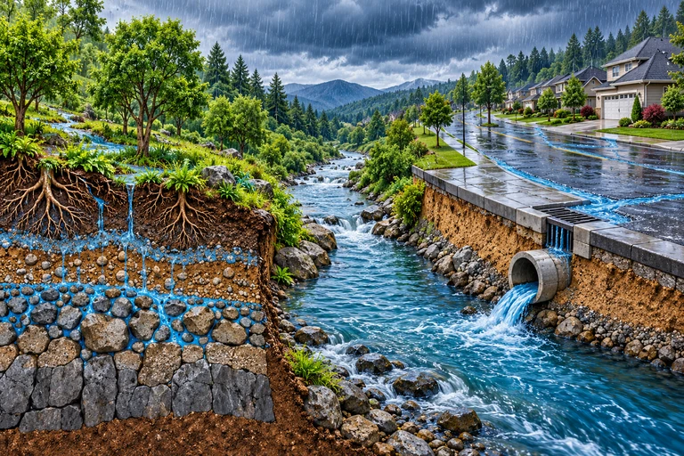 Impervious cover can change both runoff timing and volume. Storm conditions, soils and drainage control the response; infiltrated water may enter storage, evapotranspiration or later streamflow.
Connected impervious surfaces can concentrate runoff into a sharper storm response.
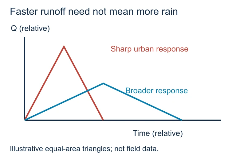 Impervious cover can change both runoff timing and volume. Storm conditions, soils and drainage control the response; infiltrated water may enter storage, evapotranspiration or later streamflow.
Example: Identifying Boundaries
Example: Runoff Calculation
A small watershed receives 80 cm/year of precipitation. Evapotranspiration accounts for 45 cm/year, and groundwater storage is stable (\( \Delta S = 0 \)). How much annual runoff exits at the outlet?
Example: Urbanization Impact
The same watershed from Slide 10 is urbanized: impervious cover increases from 10% to 60%. ET drops to 25 cm/year, storage remains stable, and precipitation stays at 80 cm.
Non-Point Source Pollution in Watersheds
Riparian Buffers: Nature's Filter
Riparian buffer zones are strips of vegetation along waterways that filter runoff, stabilize banks, and provide habitat. They are one of the most effective watershed management tools.
Common Mistakes
Watershed Concepts Summary
| Concept | Definition | AP Importance |
|---|---|---|
| Drainage Divide | Ridge separating adjacent watersheds | Determines watershed boundary |
| Pour Point | Lowest elevation outlet | Where all water exits the basin |
| Water Balance | \( P = Q + ET + \Delta S \) | Predicts runoff changes from land use |
| Impervious Cover | Surfaces water cannot penetrate | Increases runoff, decreases infiltration |
| NPS Pollution | Diffuse runoff contamination | Leading cause of water quality decline |
| Riparian Buffer | Vegetation along waterways | Filters pollutants, stabilizes banks |
Question 1 of 5
A watershed boundary is primarily determined by which of the following?
Question 2 of 5
A watershed receives \( P = 100 \text{ cm/year} \). If \( ET = 55 \text{ cm/year} \) and \( \Delta S = 5 \text{ cm/year} \), what is the annual runoff \( Q \)?
Question 3 of 5
Which of the following is the best example of non-point source pollution in a watershed?
Question 4 of 5
A forested watershed is converted to suburban development, increasing impervious surface cover from \( 5\% \) to \( 45\% \). Which outcome is most likely?
Question 5 of 5
Riparian buffer zones protect stream health primarily by doing which of the following?