Terrestrial
Biomes
Explore the major land-based ecosystems on Earth: their climate patterns, characteristic organisms, and the environmental factors that define each biome.
What Is a Biome?
A biome is a large-scale community of organisms defined primarily by the dominant vegetation type and characterized by the organisms that have adapted to that particular environment. Biomes are determined mainly by climate: temperature and precipitation patterns over long periods.
Climate Drives Biome Distribution
The two most critical climate variables that determine biome type are average annual temperature and average annual precipitation. Together, these create a "climate space" where each biome occupies a distinct zone.
The Major Terrestrial Biomes
Ecologists recognize several major terrestrial biomes. While classification systems vary, the AP Environmental Science framework focuses on these key types:
Climate and disturbance shape vegetation, roots and soil across biomes
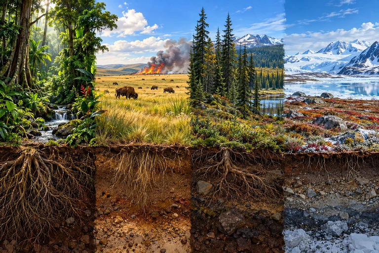 Climate, disturbance, soils and local history shape vegetation and belowground structure across biomes. Compare the plant forms and soil features that accompany different environmental conditions.
Biomes: vegetation above and below ground
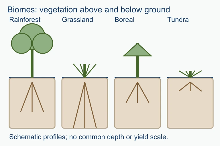 Climate, disturbance, soils and local history shape vegetation and belowground structure across biomes. Compare the plant forms and soil features that accompany different environmental conditions.
Net Primary Productivity Across Biomes
Net Primary Productivity (NPP) measures the rate at which producers in an ecosystem create useful chemical energy. It is calculated as:
Biomes with high temperature and high precipitation (like tropical rainforests) have the highest NPP. Cold or dry biomes (tundra, desert) have the lowest. This relationship is fundamental to understanding energy flow through ecosystems.
The Climate-Biome Rule
Altitude Mimics Latitude
A climate envelope climbs toward a vanishing summit
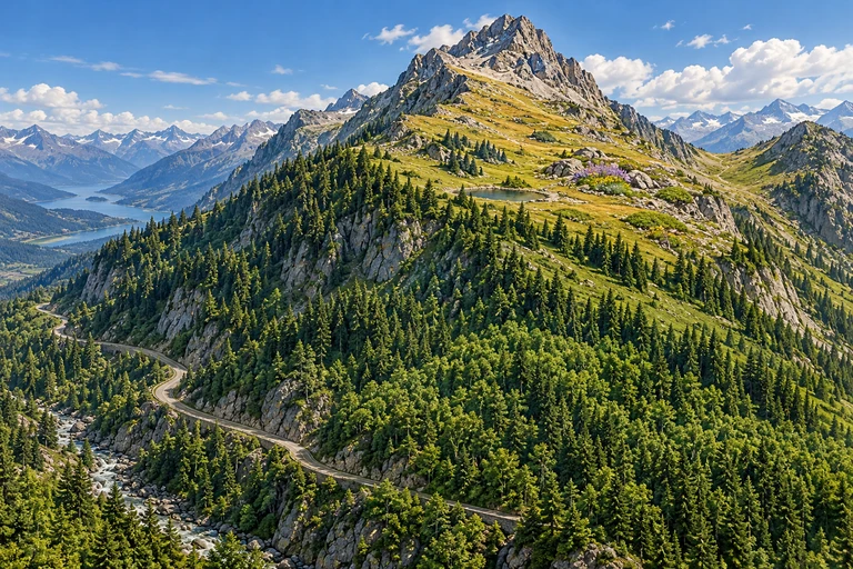 A climate band moving upward can intersect a smaller portion of a mountain as it approaches the summit. Habitat suitability and species occupancy also depend on precipitation, terrain, dispersal and barriers.
A climate envelope approaches a finite summit
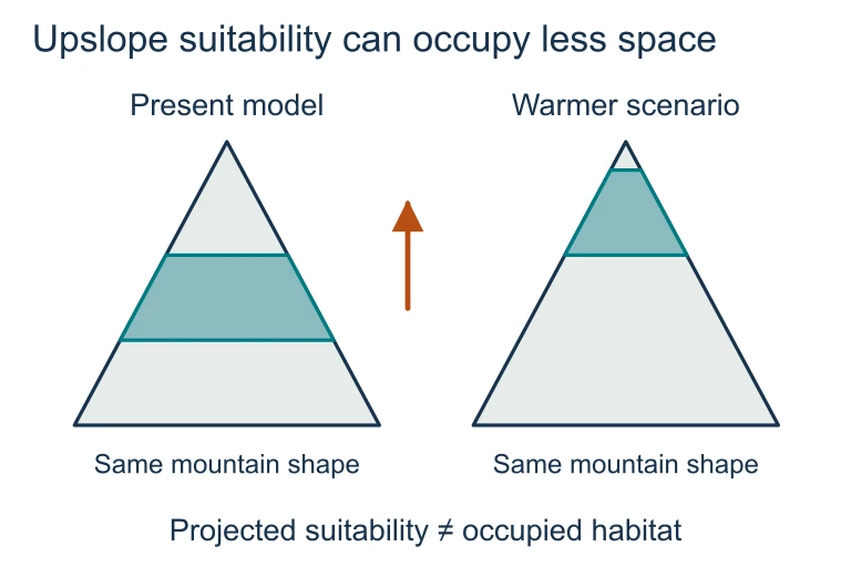 A climate band moving upward can intersect a smaller portion of a mountain as it approaches the summit. Habitat suitability and species occupancy also depend on precipitation, terrain, dispersal and barriers.
Tundra vs. Desert: Both Extreme, Very Different
Students often confuse tundra and desert because both have low biodiversity and harsh conditions. The key difference is the limiting factor:
| Tundra | Desert | |
|---|---|---|
| Limiting Factor | Temperature | Water |
| Avg. Temperature | \( -25^\circ\text{C} \) to \( -5^\circ\text{C} \) | Variable (hot or cold) |
| Precipitation | 15-25 cm/yr | \( < 25 \) cm/yr |
| Soil | Permafrost present | Sandy or rocky, no permafrost |
| Vegetation | Mosses, lichens, low shrubs | Cacti, succulents, sparse shrubs |
| Latitude | High (\( 60\text{-}90^\circ \)) | Any (often \( 30^\circ \) N/S) |
How to Identify a Biome
Example: Tropical Rainforest
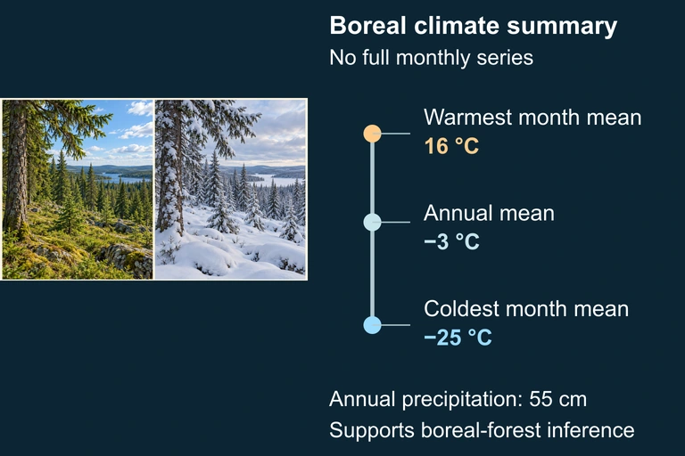
Example: Taiga (Boreal Forest)
Use seasonal climate evidence to justify a biome identification.
Use this illustration to explore the concept described in its caption.
Example: Savanna
Grassland vs. Savanna
Both biomes are dominated by grasses, but they differ in climate zone, tree density, and seasonal patterns:
| Temperate Grassland | Tropical Savanna | |
|---|---|---|
| Latitude | Mid-latitudes (\( 30\text{-}55^\circ \)) | Tropics (\( 5\text{-}20^\circ \)) |
| Temperature | Hot summers, cold winters | Warm year-round |
| Precipitation | 25-75 cm/yr | 50-130 cm/yr |
| Trees | Nearly absent | Scattered, widely spaced |
| Soil | Deep, rich (mollisols) | Thin, laterite-rich |
| Examples | Great Plains, Pampas, Steppe | Serengeti, Cerrado |
NPP by Biome
Common Mistakes
Biome Summary Table
| Biome | Temp (\( ^\circ\text{C} \)) | Precip (cm/yr) | Key Feature |
|---|---|---|---|
| Tropical Rainforest | \( 25\text{-}28 \) | 200-400+ | Highest biodiversity |
| Savanna | \( 20\text{-}30 \) | 50-130 | Wet/dry seasons, fire |
| Desert | Variable | \( < 25 \) | Water is limiting factor |
| Temperate Grassland | \( -20 \) to \( 30 \) | 25-75 | Deep, fertile soil |
| Temperate Forest | \( 5\text{-}20 \) | 75-150 | Deciduous, four seasons |
| Taiga | \( -40 \) to \( 15 \) | 30-85 | Largest biome, conifers |
| Tundra | \( -25 \) to \( -5 \) | 15-25 | Permafrost |
| Chaparral | \( 10\text{-}18 \) | 25-75 | Mediterranean, fire-adapted |
Question 1 of 5
Which two climate variables are most important in determining the type of terrestrial biome at a given location?
Question 2 of 5
A researcher measures an annual precipitation of \( 20 \) cm/yr with a mean temperature of \( -15^\circ\text{C} \) and finds permafrost beneath the surface. Which biome is this?
Question 3 of 5
Which of the following best explains why tropical rainforests have the highest net primary productivity (NPP) of all terrestrial biomes?
Question 4 of 5
A student claims that because both the Gobi Desert and the Sahara Desert receive \( < 25 \) cm of rain per year, they must have identical temperatures. What is wrong with this reasoning?
Question 5 of 5
Fire suppression in a savanna ecosystem would most likely lead to which of the following long-term changes?